
| Tourism | |
| The Village of Port Morien | |
|
Our village is one of the prettiest on
Cape Breton Island. The harbour is probably the most prominent
feature of the village and is home to an active fishing fleet,
especially during the mid-May through mid-July lobster
season. Port Morien has received recent infrastructure improvements, including sidewalks, light standards and the development of a town square. Its history is highlighted through placement of historic plaques throughout the village. Port Morien was a recipient of the Lieutenant Governors Spirit Award in 2008. Port Morien was the location of the first coal mine in North America which served the Fortress of Louisbourg during the first half of the 18th Century. Other coal mines followed during the 19th century but closed prior to World War 1. The village is also renowned as the site of the first Boy Scout troop in Canada. In addition to the scenic vistas along the Marconi trail approaching Port Morien, one of the major features of the area is the Sand Bar, located 1.5 km south. The sand bar is an ecologically significant barrier beach and tidal estuary area. The beach and estuary is a superb birding area, home to numerous wading and shore birds, gulls, ducks, Canada geese and a tern colony. It was formerly a wonderful area for clam digging on the estuary side, with quahog, snail and razor clam digging on the ocean side. Shellfish digging in the area is currently closed because of shellfish toxin characterizing this and other local areas. The ocean side of the sand bar has a beautiful sandy beach and wading area. You can walk around the sand bar in about 30 minutes. Scenic Vistas and Seaside Trails along the Marconi Trail There are numerous trails and scenic vistas along the Marconi Trail, from Glace Bay to Louisbourg. The trail follows the ocean at Big Glace Bay, Port Caledonia, Schooner Pond, Long Beach, Port Morien, Mira Bay, Catalone, Main a Dieu, Little Lorraine ending in Louisbourg. The first point of interest will be the Big Glace Bay Beach at Dearns Corner and the gas station on the left. Just past the gas station, turn left and drive along a dirt road to the Beach where one has a panoramic view of the ocean and Glace Bay. The beach and estuary here has Bird Sanctuary Status. The beach offers excellent seasonal swimming and a wonderful opportunity for a beach walk. Instead of going direct to Port Morien on Hwy 255, keep straight along Marconi Trail South through Port Caledonia and the village of Donkin. The next point point of interest is the Cape Perce Trail. This is located at Schooner Pond past the village of Donkin. There is a jut of land to the left called Cape Perce (also called the Northern Head). One can travel along the dirt road parallel to the beach to access a trail along the headland. The trail provides a close view of Flint Island and its lighthouse. The island is located between the Northern (Cape Perce) and the Southern Heads bounding Morien Bay. Another lovely walk is the Sand Bar (see above) south of Port Morien. Park your car at the highway near the entrance and have a pleasant walk. Bring your binoculars and camera. After Port Morien and the Sand Bar estuary, travel 15 km to Mira Gut on scenic Mira Bay. Located here is a parking area, a beautiful swimming beach and remnants of a Boardwalk. The beach is supervised during the July and August swimming season. Continuing along the Mira Bay the trip continues to be magnificent. The next stop is Main-a-Dieu, where there is a Discovery Centre, Boardwalk and the Moque Trail. Main-a-Dieu is another lovely fishing village with a busy fleet and an exceptional place for photos. The Moque Trail is a world class walk along the rugged ocean. Bring good walking shoes and water shoes to cross the little creek to visit the lighthouse and a great view of Scatarie Island. Another must stop is Baleine, which is just south of Main-a-Dieu. Turn left down a side road and travel to the end of the road. While there isn’t a trail there, one can walk along to the end of the gravel bar. Climb up the slope to the left and traverse the Baleine Barrens towards the ocean. Then keep right along the shore and you will be right back to the gravel bar in several hours. Bring the proper footwear for travelling across the bog and along the rocky shoreline. The view is breathtaking. Just past Little Lorraine (approximately 1.6 km), try to find one of two very rough sideroads to the left. Vehicle access is possible but difficult. The walk is approximately 10 minutes; but the scenery at Gooseberry Cove is spectacular. This is a must see! The next stop is Lighthouse Point, part of the Louisbourg National Park. Just as one enters the town of Louisbourg, take a left and drive for several kilometers along a well maintained access road. The first view to the right is of the ocean, featuring a number of rock basalt islands and the Fortress Historic Site off in a distance. After this stop, continue on to the Lighthouse at the end of the road. Beware of the foghorn! Again the views here are magnificent. At this point there is access to a new walking trail (with handicap access) along the fabulous wild Atlantic coast line. After returning to the highway, continue a short distance through the picturesque town of Louisbourg to the unforgettable Fortress Historic Site. Don’t miss Kennington Cove, by driving several kilometres past the Fortress site. This is location from which the English Soldiers descended upon the walled Fortress to defeat the French in 1759. Besides the incredible view, this is a great swimming area with parking and picnic facilities. |
 Summer sunrise in Port Morien  Port Morien lobster fleet  Sand Bar Estuary  Flint Island Lighthouse  Stormy Schooners Pond  Spring ice floes at Schooners Pond 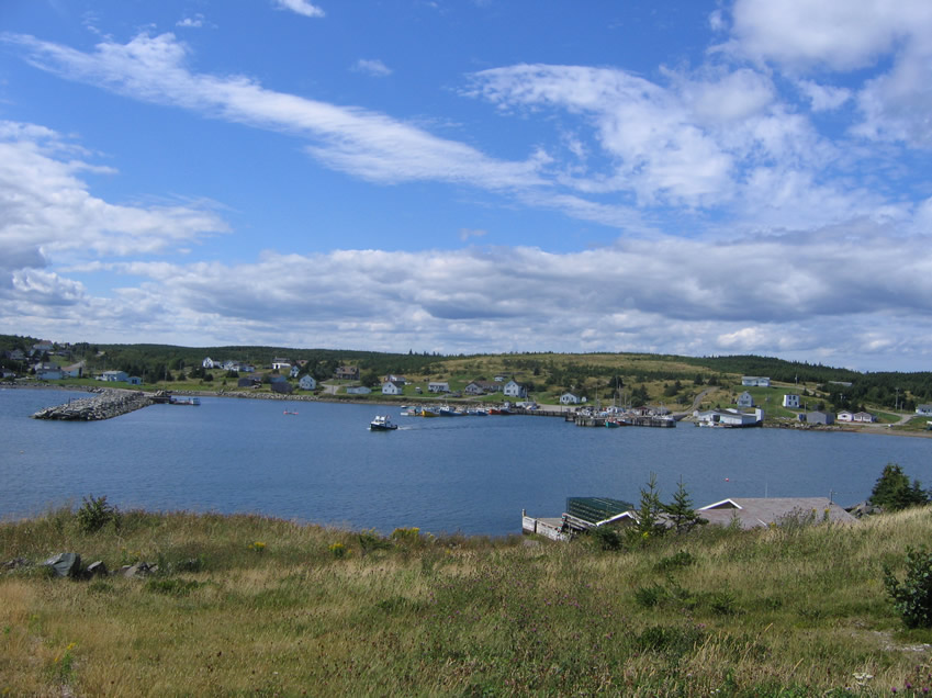 Main a Dieu  Scene along the Marconi Trail  Gooseberry Cove near Main a Dieu  Port Morien at sunset |